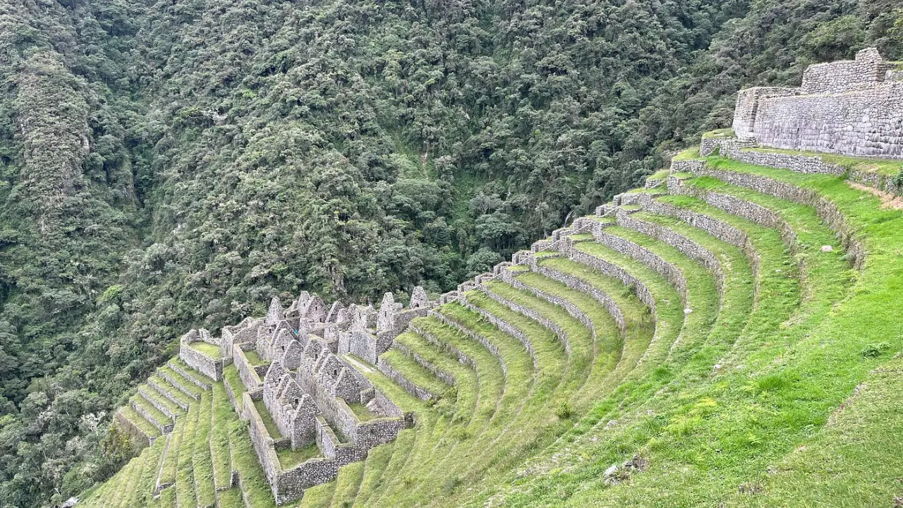
The history of the Wiñay Wayna ruins reveals one of the most complex urban and agricultural centers of the late Inca period. This archaeological site is located on a steep slope above the Urubamba River, at about 2,650 meters above sea level. Its strategic location positions it as the last major settlement before reaching the citadel of Machu Picchu. Understanding its past allows us to appreciate the engineering and spirituality that the Incas integrated into the Andean landscape.
For the modern traveler, this complex is not just a stop along the way. It represents a synthesis of the hydraulic, agricultural, and architectural knowledge of the Tahuantinsuyo. Exploring its origin and functions makes it evident that this place played a fundamental role in the road network that connected the empire’s capital with its most important religious centers.

- Origin and Meaning of the Name Wiñay Wayna
- Paul Fejos’ Expedition in 1940
- Layout of the Urban and Religious Sector
- Inca Terracing System at Wiñay Wayna
- Water Channels and Ceremonial Fountains
- Importance of Wiñay Wayna on the Inca Trail
- Distance Between Wiñay Wayna and Machu Picchu
- Current State of Conservation of the Monument
Origin and Meaning of the Name Wiñay Wayna
The name of the site comes from Quechua and is commonly translated as “Forever Young”. This meaning of the name Wiñay Wayna does not refer directly to human youth, but rather to a flower. In the surroundings of the monument, the orchid Epidendrum secundum grows abundantly, blooming throughout the year. Local inhabitants and researchers associate the persistence of this flower with the name given to the archaeological complex.
Regarding its origin and time of construction, archaeological research suggests that it was built during the 15th century. Most scholars agree that its development occurred under the reign of the Inca Pachacutec. During this period, the expansion of the empire into the cloud forest was consolidated. The construction style, featuring finely carved granite blocks, reinforces the theory that it was a high-status site within the Inca state.
Paul Fejos’ Expedition in 1940
Although local residents knew about the existence of ancient walls in the area, the site was not scientifically documented until the 20th century. Paul Fejos’ expedition in 1940 marked the beginning of the formal study of this monument. Paul Fejos, a Hungarian archaeologist and filmmaker, led the expedition under the sponsorship of the Viking Fund.
During these works, Fejos and his team cleared the dense vegetation covering the structures. They identified residential sectors, water channels, and extensive agricultural terraces. Thanks to their photographic records and detailed maps, the international community was able to realize the magnitude of the complex. Their findings showed that this place was not a simple village, but a control and resting center for the nobility.

Layout of the Urban and Religious Sector
The architecture of this site stands out for its adaptation to rugged topography. The layout of the urban and religious sector shows a clear hierarchy of spaces. The complex is mainly divided into two areas connected by a long stone staircase.
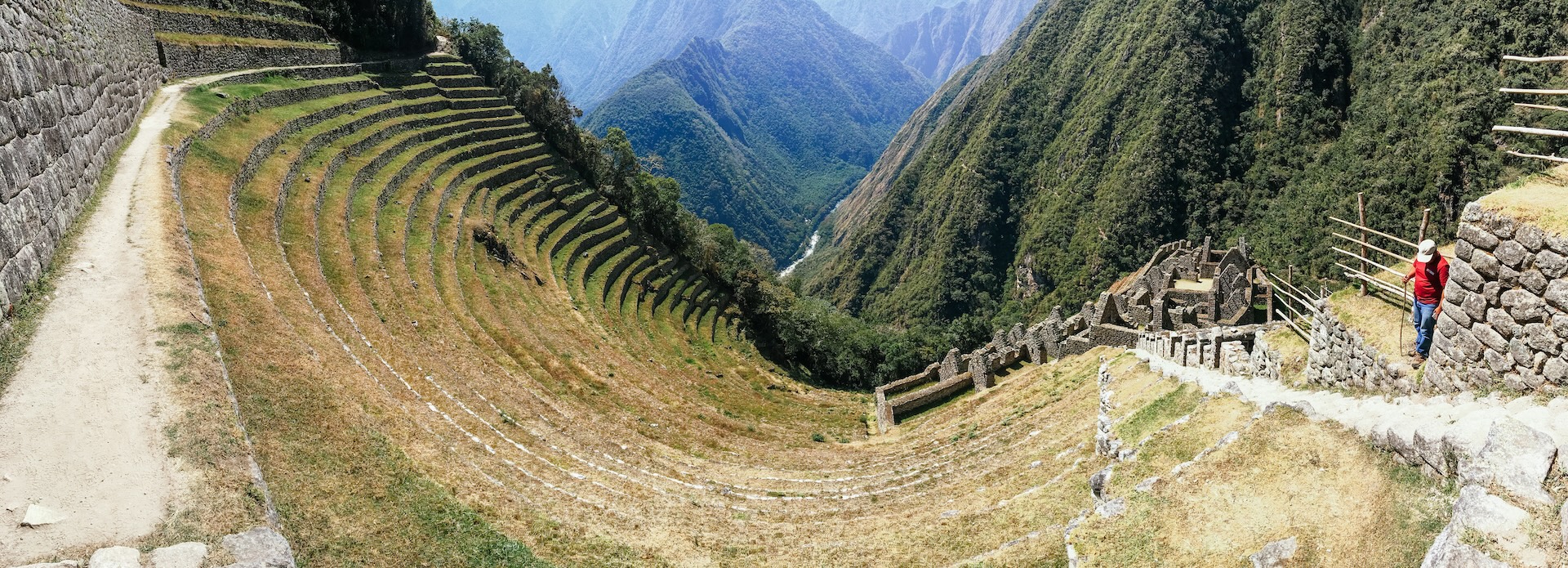
The upper sector houses residential and administrative buildings. The structures feature rectangular plans with gabled roofs, typical of imperial architecture. In the lower sector, there are structures with higher quality stonework. Among them, a semicircular building stands out, which archaeologists associate with ritual functions. This enclosure offers a panoramic view of the valley, suggesting an astronomical or religious observation function.
Trapezoidal niches in the interior walls are another distinctive feature. These spaces were used to place ceremonial objects or idols. The precision of the stone joints in the main enclosures indicates that the site housed an administrative or priestly elite responsible for the worship of the sun and water.
Inca Terracing System at Wiñay Wayna
One of the most visible features of this monument is its impressive Inca terracing system at Wiñay Wayna. Agricultural terraces extend along the hillside, following the natural contour lines of the terrain. These terraces served not only for food production, but also played a critical structural role.
- Erosion control: The terraces prevented landslides in an area with high rainfall.
- Soil optimization: They allowed the cultivation of crops in different microclimates according to the height of each platform.
- Efficient drainage: The design of the internal layers of the terraces facilitated rainwater drainage.
It is estimated that crops destined for the consumption of pilgrims and residents of Machu Picchu were grown on these platforms. Corn and coca were likely priority crops due to their ritual value. The history of the Wiñay Wayna ruins is intrinsically linked to this ability to transform hostile mountains into productive land.
Water Channels and Ceremonial Fountains
Water management in this complex is a testament to the advanced hydraulic engineering of the Incas. Numerous water channels and ceremonial fountains running parallel to the main staircase have been identified throughout the site. These fountains, also called “baths of the Inca”, are fed by natural springs located in the upper areas.
There are ten consecutive fountains that operate by gravity. Water flows from one to another with a constant sound that adds a sensory component to the environment. This was not just a functional supply for human consumption. These fountains served a spiritual purpose related to purification. Travelers heading to the sacred city had to perform cleansing rituals before continuing their journey.
Importance of Wiñay Wayna on the Inca Trail
The importance of Wiñay Wayna on the Inca Trail is key to understanding the empire’s logistics. In the Andean road system, this site functioned as a high-status “tambo” or lodging place. Due to its proximity to the final destination, it served as the final preparation point for those arriving from Cusco.
The trail connecting this complex to the citadel is one of the best preserved. The path is paved with granite blocks and traverses cloud forests with remarkable biodiversity. The location of this settlement made it possible to control access to the sacred area. Guards stationed here verified who was authorized to enter the restricted area of Machu Picchu.
If you are planning a trek along this route, it is advisable to get information from specialists like Trails to Machu Picchu. They can provide details about necessary permits and the best seasons to hike these historic trails. Knowing the history of the Wiñay Wayna ruins before arriving significantly enhances the visitor experience.
Distance Between Wiñay Wayna and Machu Picchu
For those taking the journey on foot, the distance between Wiñay Wayna and Machu Picchu is relatively short yet exciting. The route covers approximately 5 kilometers of paved trail. Regarding hiking time, it usually varies between an hour and a half and two hours, depending on the hiker’s pace.
The final stretch includes passing through Intipunku or the Sun Gate. From this point, you get the first panoramic view of the citadel. Most trekking groups camp near the archaeological site to start the final leg at dawn. This strategic proximity reinforces the theory that the complex was a first-rate defensive and administrative outpost.

Current State of Conservation of the Monument
The current state of conservation of the monument is generally good, thanks to continuous intervention by Peru’s Ministry of Culture. As the site receives a steady flow of visitors, authorities have implemented strict measures to protect the original structures. Visitors cannot touch the walls, and authorities have designated specific paths to prevent soil wear.
However, the natural environment presents ongoing challenges. High-jungle humidity and parasitic vegetation growth require periodic cleaning of the stones. Authorities perform maintenance work on water channels to prevent seepage that could destabilize the agricultural terraces. Only visitors with an Inca Trail permit can access the site, helping authorities control the impact of mass tourism.
It is important for visitors to respect preservation rules. The history of the Wiñay Wayna ruins must be protected for future generations. Avoiding littering and following the instructions of SERNANP park rangers is essential to keep this heritage site in optimal condition.
Visiting this site allows you to understand the Inca worldview at its finest. Here, nature and human construction do not compete; instead, they complement each other. The sound of water, the presence of orchids, and the solidity of granite walls create an atmosphere of serenity. This archaeological complex remains a benchmark for understanding the social and technical complexity of one of the most advanced civilizations in the Americas.
Trails to Machu Picchu can help you book and organize your route in advance, contact us.